Why, we take it slow and easy in Nauvoo

Two of the main streets in Nauvoo, are Main Street, running North and South through old Nauvoo and Parley Street, running East and West from the Mississippi River to the old Cemetery.  Each street is all of two miles long and consist of 20 feet of asphalt and generally no sidewalks.

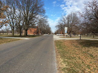
This picture is Main St. looking to the North, which is just a 100 feet from our home, please notice the speed limit sign.                    


This is again Main St. looking to the South, right next to the Cultural Hall, again notice the speed limit sign.

This is Parley St. looking East from our home, the speed limit sign is in back of us, guess what the max. speed is?

This is the East end of Parley, going out of town to the cemetery, at 20 MPH of course.


Least you think we do not have a drag strip in town, this is the downtown area, the Temple is just to the left of the water tank and you can go all of 25 MPH.  I think they have one policeman in town and he gets a lot of sleep.  
Comments

Popular posts from this blog

Orville and Alma Hummel

With the help of David Leininger, the grandson of the original owner, we have discovered two homes, located in the back woods of Nauvoo, which were constructed in the mid 1800's and were lived in by Orville and Alma Hummel.  David's mother, Analie is now 99 years old, and knew the Hummels and went to school with their son, Kenneth.                                                                                                                                          Orville and Alma Hummel, were born in the 1890's and lived in these homes during the first world war and paid $ 5 per month rent to George Leininger, Analie's father. Orv...

Mississippi River

Flowing on three sides of Nauvoo, is the Big Muddy, commonly known as, the Mississippi River, is extremely important to residents of the mid west. We saw this mile wide river completely freeze in two days this winter. In Feb. of 1845, the pioneers crossed on ice.              Barge on the Mississippi River Farmers around here produce mostly corn and soy bean.  About a third is for humans, a third is for gas, and the last third is for animals.  Trucks and trains haul produce to the river banks where it is loaded on to barges. Silos used to load the barges These barges consist of 15 individual barges, connected together and pushed by one tug boat.  Each set of barges can transport as much produce as 788 semi truck loads.  They take the coal and farm products to New Orleans where it is shipped as far away as China. Tug Boat pushing the barge As the barges move up and down the river, they cross many bridges, us...